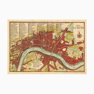
Prospect of medieval London Bridge covered with houses NICHOLLS, Sutton. The West-Side of London-Bridge. The East-Side of London-Bridge. London: John Smith, c.1705. Coloured. Two sheets conjoined, total 570 x 880mm. Elevations of either side of London Bridge at the beginning of the 18th century, filled with buildings, the longest inhabited bridge ever built in Europe. The west view illustrates the ferries and river craft upstream of the bridge, including one seeming about to 'shoot the bridge', braving the rapids caused by the piers; the east view shows the ocean-going vessels that could not pass the bridge. Underneath is a text, 'An Historical of the great and admirable Bridge in the City of London over the River Thames', taken from John Stow's 'Survey of London', and a poem, 'Of London-Bridge, and the Stupendous Site, and Structure thereof', originally in the preface of James Howell's 'Londinopolis'. The buildings shown here were all rebuilt between 1683 and 1696, when it was specified there had to be a roadway 20 feet wide. They were destroyed by fire in 1725, rebuilt, and finally cleared following the 1756 Act of Parliament. John Rennie's new bridge was built slightly upstream in 1831, after which the old bridge was demolished. Nicholls, the engraver, worked for a number of map publishers. He engraved some of the Morden county maps and updated the Saxton plates for Philip Lea. GERHOLD: 'London Bridge and its Houses', 2019.
Perspectiva del puente medieval de Londres cubierto de casas NICHOLLS, Sutton. El lado oeste del puente de Londres. The East-Side of London-Bridge. Londres: John Smith, c.1705. Coloreado. Dos hojas unidas, total 570 x 880 mm. Alzados de ambos lados del Puente de Londres a principios del siglo XVIII, repleto de edificios, el puente habitado más largo jamás construido en Europa. La vista oeste ilustra los transbordadores y las embarcaciones fluviales río arriba del puente, incluida una que parece a punto de "disparar al puente", desafiando los rápidos provocados por los pilares; la vista este muestra los buques oceánicos que no podían pasar el puente. Debajo hay un texto, "An Historical of the great and admirable Bridge in the City of London over the River Thames", tomado del "Survey of London" de John Stow, y un poema, "Of London-Bridge, and the Stupendous Site, and Structure thereof", originalmente en el prefacio de "Londinopolis" de James Howell. Todos los edificios que se muestran aquí fueron reconstruidos entre 1683 y 1696, cuando se especificó que debía haber una calzada de 6 metros de ancho. Fueron destruidos por un incendio en 1725, reconstruidos y finalmente desalojados tras la Ley del Parlamento de 1756. El nuevo puente de John Rennie se construyó ligeramente río arriba en 1831, tras lo cual se demolió el antiguo. Nicholls, el grabador, trabajó para varios editores de mapas. Grabó algunos de los mapas del condado de Morden y actualizó las planchas de Saxton para Philip Lea. GERHOLD: "El puente de Londres y sus casas", 2019.


Contacta con nosotros
Haz una oferta
¡Hemos notado que eres nuevo en Pamono!
Por favor, acepta los Términos y condiciones y nuestra Política de privacidad
Contacta con nosotros
Haz una oferta
¡Ya casi está!
Para seguir la conversación en la plataforma, por favor completa el registro. Para proceder con tu oferta en la plataforma, por favor completa el registro.Exitoso
Gracias por tu consulta, alguien de nuestro equipo se pondrá en contacto contigo en breve.
Si eres profesional del diseño, por favor solicita aquí los beneficios del Programa comercial de Pamono